madbookings
Real people · No booking fees · 30+ years in Southern Africa

The complete guide · Shipwrecks · Seals · Desert lions · Fog

Skeleton Coast.

A land of shipwrecks half-buried in dunes, seal colonies a quarter-million strong, fog rolling in off a freezing Atlantic, and desert-adapted elephants walking dry riverbeds a hundred kilometres from open water. The Skeleton Coast is Namibia at its most raw — and its most rewarding, if you understand the two-zone rule that governs the whole trip.

SKELETON COAST · SOUTH → NORTH SOUTHERN ZONE · SELF-DRIVE OK NORTHERN ZONE · PERMIT + GUIDE ONLY SWAKOPMUND KM 0 · FUEL HENTIES BAY KM ±70 · LAST FUEL! CAPE CROSS KM ±120 · SEALS UGAB GATE · PARK ENTRY ZEILA shipwreck EDUARD BOHLEN 300 m inland · in dunes TORRA BAY DEC/JAN ONLY TERRACE BAY KM 359 · END OF SELF-DRIVE HOARUSIB DESERT ELEPHANTS HOANIB DESERT LIONS MOWE BAY FLY-IN ONLY KUNENE RIVER ANGOLAN BORDER FILL UP AT SWAKOPMUND AND HENTIES BAY · NOTHING RELIABLE BEYOND

The coast in one line — two zones, three fuel points, four shipwrecks, one Kunene River finish

The stretch
Swakopmund → Kunene River · ~500 km
The two zones
South = self-drive · North = permit + guide only
The fuel
Swakopmund & Henties Bay ONLY
The Cape Cross seals
Up to 250,000 in colony

01Where the Skeleton Coast is

The Skeleton Coast runs along Namibia's Atlantic coast from Swakopmund in the south to the Kunene River in the north — the border with Angola. Most of that ~500 km strip is protected as Skeleton Coast National Park, part of the greater Namib Desert, one of the world's oldest deserts.

This is the place where the Namib Desert dunes crash directly into the cold Atlantic. There are no cities. No crowds. Fog rolls in off the ocean most mornings. Wind carves the dunes constantly. Shipwrecks lie half-buried where the surf gave up on them. It's Africa's version of the world's edge.

Practically, though, you should think of the coast as two very different places — see section 2. What you can do depends entirely on which one you're in.

Namib dunes meeting the cold Atlantic at the Skeleton Coast on a foggy morning
Where desert meets ocean — the defining Skeleton Coast image

02The two-zone split — where the access rules divide

The single most important thing to understand about the Skeleton Coast: the southern half is accessible; the northern half is not, unless you're on a guided permit or fly-in stay. This isn't bureaucracy — it's how a fragile ecosystem gets protected. Plan around the split.

Ugab River → Torra Bay · Self-drive

The southern zone

Runs from the Ugab River in the south up to Torra Bay. Access is via the C34 salt road — a compact surface drivable in a normal 2WD in good conditions, though a 4×4 is strongly recommended for anything off-tar. Park entry is a standard ticket bought at the gate. You can self-drive freely and stay at rest camps or lodges along the way.

Includes: Cape Cross Seal Reserve · Zeila & Eduard Bohlen shipwrecks · dune fields · viewpoints

Terrace Bay → Kunene River · Restricted

The northern zone

From Terrace Bay north to the Angolan border. Highly restricted, protected wilderness — accessible only via guided 4×4 safari or fly-in stay at a remote lodge. Permits are mandatory and arranged by operators. This is where the true Skeleton Coast wilderness lives: Hoarusib and Hoanib riverbeds, desert-adapted elephants and lions, the Dunedin Star shipwreck, Mowe Bay.

Includes: Hoanib & Hoarusib · desert elephants & lions · Mowe Bay · northern shipwrecks

The northern zone is not "you can try to talk your way in" Rental cars are not permitted beyond Terrace Bay. Even if you have the vehicle to reach it, without a permit and registered guide you'll be turned away — and the fine, plus the retrace back down 400 km of gravel, is not the trip you paid for. Book properly.

03Getting there & realistic distances

Three ways to reach the Skeleton Coast, in order of use:

  • Self-drive from Swakopmund — the standard approach. Windhoek to Swakopmund is 4–5 hours; most travellers overnight in Swakopmund before heading north. From there the coastal C34 runs north through Henties Bay, past Cape Cross, into the park via the Ugab Gate
  • Guided 4×4 safari — the mandatory option for the northern zone. Reputable operators handle vehicles, permits, guides, fuel and food
  • Fly-in to a remote lodge — small charter planes from Windhoek and Swakopmund land on airstrips near the northern lodges. Fastest, most scenic, most expensive — and often the only way to get to the true wilderness camps

Real distances

Coastal gravel is slower than you think — plan on 50–70 km/h average, even on the salt road, once conditions are anything but dry.

FromToDistanceApprox driving
WindhoekSwakopmund±360 km4–5 hours (tar)
SwakopmundHenties Bay±70 km1 hour (salt road)
Henties BayCape Cross Seal Reserve±60 km1 hour
Cape CrossTerrace Bay±230 km3–4 hours
SwakopmundTerrace Bay (total)±359 km5–6 hours (gravel)
Terrace BayMowe Bay±150 kmGuided/fly-in only

The 4×4 question: for the C34 salt road in dry weather a normal sedan technically works. For anywhere else — access tracks to campsites, riverbeds, or heavy conditions — you need a proper 4×4. Details in our car hire guide.

04Top things to see & do

Every landmark from the coastal timeline above, with what to expect and how to visit it.

Southern zone · KM ±120 · Wildlife stop

Cape Cross Seal Reserve

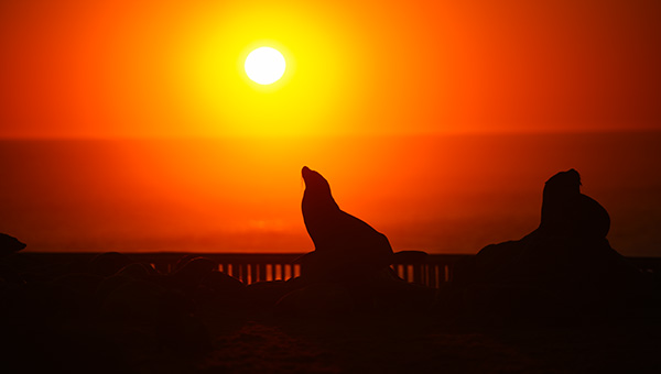
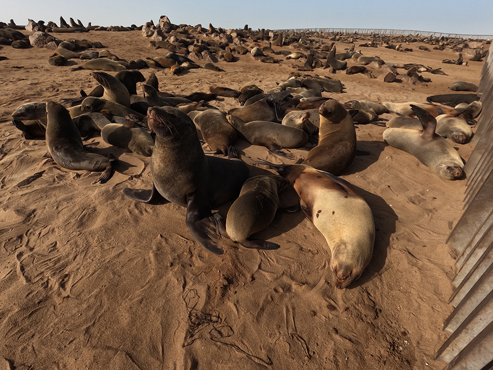
One of the world's largest colonies of Cape fur seals — up to 250,000 seals in peak breeding season. Wooden walkways let you observe them at close range. Expect unbelievable noise, dramatic behaviour and an aroma that stays with you for hours. Fascinating and unforgettable.

Southern zone · Multiple stops · Photography

The shipwrecks

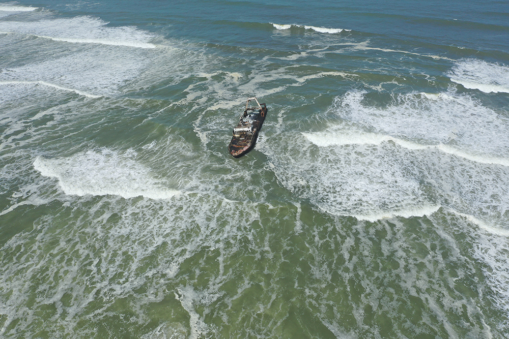
The coast is dotted with skeletal remains of ships broken by fog, current and reef. The three most-visited: Zeila (the most photogenic, easy to reach, glorious at sunrise or in fog), South West Seal (visible from the C34, often half-buried), and Eduard Bohlen — one of the country's most iconic wrecks, now lying 300 metres inland where the dunes have swallowed it.

Southern & northern · Early / late · Landscape

The Skeleton Coast dunes

The dunes shift constantly, sculpted by wind and often wrapped in Benguela fog. They stretch to the ocean and create the coast's signature contrast — sand meeting sea meeting sky. Early morning or late afternoon are best; noon light is flat. Some of Namibia's finest aerial photography comes from here — think about a scenic flight.

Northern zone · Guided only · Wildlife

Hoanib & Hoarusib riverbeds

Dry riverbeds that support desert-adapted elephants, giraffes, and (in the Hoanib) desert lions. Even without visible water, the underground aquifers sustain a whole ecosystem. Guided drives through these riverbeds are the only way in and are one of Africa's true wilderness safaris. See our Damaraland guide for the wider desert-elephant context.

Northern zone · Fly-in usually · Remote

Mowe Bay

A remote outpost deep inside the park with a small museum on the natural and maritime history, old industrial machinery from earlier mining efforts, a colony of seals along the shore, and the nearby South West Seal shipwreck. The atmosphere is haunting — cold Atlantic against endless dunes, almost no development, silence except wind. Usually visited as part of a fly-in lodge excursion.

Southern zone · Dec/Jan · Fishing

Shore fishing

Popular along parts of the coast, especially around Terrace Bay and the seasonal Torra Bay camp (open only in December and January, when hundreds of Namibian and South African fishermen descend). Local licence and permit rules apply. Not the primary reason most international visitors come, but a signature Namibian ritual worth understanding.
05Wildlife & the Benguela fog

The Skeleton Coast is where a cold ocean current meets a hot desert, and everything about the ecosystem here follows from that collision.

The Benguela — the coast's engine

The Benguela Current flows north up the Namibian coast, bringing cold Antarctic-source water — around 14–18°C — right against the shore. When warm desert air meets this cold water, it condenses into the dense fog that sits over the coast most mornings. That fog is what keeps the whole desert ecosystem alive: many desert plants, insects and small reptiles depend on the fog for their water. It's also why the coast feels colder than "desert" implies, and why the shipwrecks piled up before radar.

The wildlife you can see

  • Cape fur seals — Cape Cross's quarter-million-strong colony is the headline, but there are smaller colonies at Mowe Bay and along the coast
  • Desert-adapted elephants — Hoanib and Hoarusib riverbeds, northern zone. Extraordinary animals that walk enormous distances between water sources
  • Desert lions — the coast is home to one of the world's rarest lion populations, adapted to hunt seals and jackals along the shoreline. Very hard to see; requires expert guides
  • Giraffe, oryx, springbok, ostrich — desert generalists, best in the northern riverbeds
  • Brown hyena — elusive; ranges along the shore for what the surf leaves behind
  • Black-backed jackals — the shoreline's opportunist patrollers
  • Birdlife — flamingos, pelicans, terns, cormorants; seabirds year-round; Ramsar-quality wetlands at the river mouths

Desert-adapted lions and elephants are the marquee wildlife of the Skeleton Coast — but sightings require the northern-zone guided access. Southern-zone travellers will see seals, jackals, birds, and (with luck) the occasional desert-adapted general fauna. Adjust expectations to your zone.

A quarter of a million Cape fur seals along the shoreline at Cape Cross Seal Reserve
Cape Cross — the noise, the smell, the sheer scale

06History & the shipwrecks

The name is grim and honest. Skeleton Coast comes from the whale and seal bones littering the beaches — some naturally deposited, many from the early-1900s whaling boom that stripped the southern Atlantic. Whale and seal skeletons still wash up every year; the coast keeps adding to its own name.

To that were added the shipwrecks. The combination of dense Benguela fog, powerful currents, unmapped reefs and open ocean turned this coast into a graveyard for ships. Even in the age of GPS, wrecks pile up occasionally. Every ship has a story:

  • Zeila (2008) — a fishing trawler that broke free while being towed. Still one of the most photographed wrecks on the coast, its skeleton silhouetted against the Atlantic surf
  • Eduard Bohlen (1909) — a German cargo ship stranded in fog. The desert has since reclaimed her — she now lies 300 metres inland, hull disappearing into dunes. One of the most surreal photographs in Namibia
  • South West Seal — a fishing vessel visible from the C34 south of Cape Cross, often half-buried
  • Dunedin Star (1942) — the northern coast's most famous wreck, subject of one of the great southern-African rescue stories. Barely accessible today; visited on fly-in lodge excursions

Add to these the old industrial remains around Mowe Bay — machinery from earlier attempts at mining, guano collection and fishing — and you have a coast whose human history is essentially a series of ambitious failures that nature quietly took back.

07Where to stay

Accommodation on the Skeleton Coast is remote and spread far apart — no big resorts, no clusters of hotels, no rushing between options. Book early and plan the route carefully; the distance between stays can be four hours of gravel.

Inside the park

National park · Simple · Fishing base

Terrace Bay Camp

Basic but practical rooms inside Skeleton Coast National Park, mainly used by travellers exploring the park by 4×4 or fishing. Facilities are modest but the location is direct — you're on the quiet northern coastline, at the very end of the self-drive stretch.

Northern zone · Luxury · Iconic

Shipwreck Lodge

Cabins designed to look like weathered old shipwrecks, inspired by the coastline they sit on. Luxury lodge with meals and guided activities (nature drives, wildlife tracking). Because of the remoteness, access is arranged through the lodge itself, usually by 4×4 transfer or small aircraft. The signature Skeleton Coast luxury experience.

Seasonal · Dec–Jan only · Camping

Torra Bay

Seasonal campsite open only in December and January — the peak fishing season, when hundreds of local fishermen descend. Basic; no permanent structures. Bring everything you need.

Outside the park

Coastal road · Self-catering · Budget

Mile 108 Rest Camp

South of the main park area on the road between Swakopmund and Henties Bay. Self-catering chalets and campsites. A budget-friendly stopover that gives you access to the same coastal landscape in a more accessible location.

Seasonal · Dec–Jan · Fishing camp

Mile 72

Only open December and January, close to Henties Bay. Individual campsites accommodate up to eight people; both day and overnight campers welcome. A fisherman's spot with a devoted following.

Family-friendly · Camping · Between towns

Jakkalsputz

Between Henties Bay and Swakopmund. Campsites for up to six people, communal areas, ablution blocks, water points and small kiosks for essentials. Ideal for families and small groups looking for coastal camping without the extremes.

Cape Cross · Lodge · Comfort

Cape Cross Lodge

Near the Cape Cross seal colony. Comfortable rooms, restaurant, ocean views — easier to reach than the park lodges. Staying here lets you visit the seal colony early or late, when it's less crowded. A strong pick for travellers wanting comfort without going deep into the park.

A common rhythm: one or two nights near Cape Cross for the southern-zone highlights, plus a fly-in stay at Shipwreck Lodge or a northern camp if the wildlife is the priority. For a Windhoek or Swakopmund night to book-end the trip, see the wider Complete Guide to Namibia.

08Best time to visit

The Skeleton Coast has a dry desert climate cooled dramatically by the ocean. Temperatures are mild by Namibian standards; the weather itself changes fast.

May – September: dry winter — best for most

Daytime 18–25°C, nights that can drop close to 0°C. Benguela fog is frequent, creating that mystical atmosphere along dunes and shipwrecks. Best season for wildlife viewing — animals concentrate near riverbeds — and roads are firmer and easier to drive. Layers essential.

November – March: summer — hot & hazy

Daytime 20–30°C, warmer inland but coast stays relatively mild thanks to the Benguela. Rain is rare but possible in short bursts. Foggy mornings, dramatic light for photography. December and January are the fishing peak — Torra Bay and Mile 72 open, coastal camps fill with Namibian and South African visitors; accommodation availability is severely limited.

April & October: shoulder sweet spot

18–28°C, occasional fog and wind, thinner crowds, more relaxed. If you can choose freely, these two months balance conditions and quiet best.

The coast is windy year-round, especially in the afternoons. Atlantic waters stay 14–18°C — swimming is not a thing here. Cross-check with our when-to-visit Namibia guide for the wider trip.

Namib dunes meeting the cold Atlantic at the Skeleton Coast on a foggy morning
Where desert meets ocean — the defining Skeleton Coast image

09Packing, fuel & cash — the practical realities

What to pack

  • Layers — always layers. Foggy mornings can be near-freezing; midday can climb to warm. Lightweight breathable base + warm jacket + windbreaker
  • Sturdy hiking shoes or boots for walking on hot sand, gravel and uneven terrain. Sandals for lodges only
  • Wide-brim hat, sunglasses, SPF 50+ sunscreen — sand and water double the reflection
  • Extra water and snacks — services are limited; carry more than you think
  • Binoculars & camera — wildlife spotting and landscape photography are the whole point
  • Offline maps (Maps.me / OsmAnd) downloaded before you leave — cell signal disappears fast
  • First-aid kit & medication — see our malaria & health guide for the full list. Skeleton Coast is malaria-free; sun and heat are the bigger risks

Fuel — the rule that decides your trip

Fuel exists only in Swakopmund and Henties Bay. There is nothing else guaranteed on the coast. Fill up in both. Carry extra jerry cans if going beyond. Never drop below half a tank. Range-anxiety on the Skeleton Coast is a real problem people have every year.

Cash & cards

  • Withdraw cash in Windhoek or Swakopmund — reliable ATMs, more choice
  • Many lodges, camps and fuel stations accept cards, but connectivity for payments is unreliable — carry NAD cash as backup
  • Small notes for tips, fishing permits and small purchases; larger notes for fuel and lodges
  • Nothing beyond Swakopmund or Henties Bay has ATMs

Cell & WiFi

  • Swakopmund — reliable signal, hotel WiFi widely available
  • Inside the park — weak to non-existent. Some lodges offer WiFi in main areas only (slow, patchy)
  • Northern zone — no signal. Sat phone worth renting for remote self-drive; lodges have satellite comms in emergencies

Tell someone your route and expected arrival before you drive north. Solid old-fashioned advice that matters on this coast more than most.

10Rules, permits & travelling with children

The rules that matter

  • Park permits are mandatory in the southern zone — bought at Ugab Gate. In the northern zone, special permits are required and must be arranged in advance via lodge or guided-tour operator
  • No off-track driving. The desert ecosystem is fragile and tyre tracks last decades. Stick to established routes
  • No fires outside designated lodge or campsite areas — camping in undesignated spots is forbidden
  • Feeding animals is prohibited — for your safety and their behaviour
  • Fishing requires a local permit and follows local regulations. Buy permits at lodges or park offices
  • Northern zone access requires a registered guide. Rental cars are not permitted beyond Terrace Bay. Do not attempt it
  • Some areas close seasonally or during heavy fog and wind for safety reasons

Travelling with children

Yes, with careful planning. Cape Cross, exploring dunes, seeing shipwrecks — all can be memorable for older kids. Lodges like Shipwreck Lodge or Cape Cross Lodge are safer for families than the campsites, especially with young children.

  • Very young children may struggle with the long gravel drives and cold, windy conditions — assess honestly
  • Constant supervision near cliffs, dunes, riverbeds and the ocean — terrain can be uneven and slippery
  • Carry ample water, sun protection, and layers for temperature swings
  • Confirm the lodge's minimum-age policy before booking — some northern camps restrict very young children
The Zeila shipwreck skeleton silhouetted against Atlantic surf in soft morning fog
The Zeila at first light — one of the coast's most-photographed images

11Practical FAQs

Where is the Skeleton Coast?

The Atlantic coast of north-western Namibia, stretching from Swakopmund in the south to the Kunene River (Angolan border) in the north. Most of it lies inside Skeleton Coast National Park, part of the greater Namib Desert.

Can I self-drive?

Yes, but only the southern zone — Swakopmund up to Terrace Bay. The C34 salt road is drivable in a normal 2WD in good conditions, though a 4×4 is strongly recommended. The northern zone (beyond Terrace Bay) is permit-and-guide only, or fly-in to a lodge.

Where can I get fuel?

Only Swakopmund and Henties Bay have fuel stations. Nothing beyond Henties Bay is guaranteed. Fill up in both, carry extra fuel if going deeper, and never drop below half a tank.

Do I need a permit?

Southern zone: standard park entry ticket at the Ugab Gate. Northern zone: special permits, only accessible with a registered guide or on a fly-in lodge stay — arranged by the operator, not at the boom.

Will I see the desert-adapted elephants and lions?

Only in the northern zone — Hoanib and Hoarusib riverbeds — which is permit-and-guide access only. Southern-zone visitors won't see them here. For the wider desert-elephant experience see our Damaraland guide.

How long should I stay?

Two to four nights is the sweet spot for the southern zone (Cape Cross plus shipwrecks plus dunes). Add two or three nights at a northern fly-in lodge for the wilderness experience — worth the outlay for anyone whose priority is the wildlife.

Is it safe for children?

Yes, with supervision and sensible planning. Lodges are easier than campsites for families. Distances are long, weather is cold and windy, medical facilities are limited — pack for temperature swings and confirm minimum-age policies for northern camps.

Can I combine Skeleton Coast with Etosha or Damaraland?

Absolutely — they pair naturally. A common loop: Windhoek → Etosha → Damaraland → Skeleton Coast (southern zone) → Swakopmund → Sossusvlei → Windhoek. See our self-drive planning guide for the classic 14-day route.

Is the water safe to swim in?

You can, technically. Between the 14–18°C water temperature and the strong currents, most people don't. Wading and beach walks are the norm; serious swimming is a wetsuit-and-experience activity here.

Section 12 · Tick it off

The Skeleton Coast checklists

Before you drive north

The day bag

On the road

The three-line rule for the Skeleton Coast: fill up in Henties Bay, respect the northern-zone permit line, and let the coast set the pace — this is not a place to rush.

↑ Back to contents

The right zone. The right lodge. The right permits.

We book the Skeleton Coast trip that actually delivers

Northern-zone permits arranged properly. Fly-in stays at Shipwreck Lodge and the wilderness camps. Southern-zone self-drive route with Cape Cross, the Zeila and the shipwreck sequence built in. And the right 4×4 with the extra jerry can, because fuel maths matter here more than anywhere else in Namibia. Real people, no fees on top.

Plan my Skeleton Coast    or WhatsApp us directly

No extra fees

You pay each place's own rate — nothing on top.

Best matches

The right lodge for your zone, not the cheapest quote.

Expert advice

First-hand, from people who drive this coast.

Friendly, fast service

Real people, replies usually the same day.