Search all Namibia Accommodation

|
 Places to stay in
 Popular places in NamibiaNamib Desert Area Etosha National Park Fish River Canyon Accommodation GuidePlaces to stay around Namibia South Namibia Central Namibia Northern Namibia Coastal Namibia |

Namibia Essential
|
Travel Guide to
|
Fish River Canyon - Namibia
The Fish River Canyon is located the south of Namibia. It is the second largest canyon in the world and the largest in Africa, as well as the second most visited tourist attraction in Namibia. It features a gigantic ravine, in total about 100 miles (160 km) long, up to 27 km wide and in places almost 550 metres deep.
 The
Fish River at 650 kilometres is the longest interior river in Namibia
Its source lies in the eastern Naukluft Mountains and flows south-west
of Ai-Ais into the Oranje River. It cuts deep into the plateau which is
today dry, stony and sparsely covered with hardy drought-resistant plants.
The river flows intermittently, usually flooding in late summer; the rest
of the year it becomes a chain of long narrow pools. At the lower end
of the Fish River Canyon, the hot springs resort of Ai-Ais is situated.
The
Fish River at 650 kilometres is the longest interior river in Namibia
Its source lies in the eastern Naukluft Mountains and flows south-west
of Ai-Ais into the Oranje River. It cuts deep into the plateau which is
today dry, stony and sparsely covered with hardy drought-resistant plants.
The river flows intermittently, usually flooding in late summer; the rest
of the year it becomes a chain of long narrow pools. At the lower end
of the Fish River Canyon, the hot springs resort of Ai-Ais is situated.
Because the Fish River is being dammed in Hardap near Mariental, it only contains a small amount of running water. In winter, during the dry season, the river bed is often completely dry or reduced to only the occassional puddle. However, after rainfalls in summer the river can become a raging torrent.
The canyon starts near Seeheim, is 161 kilometres long and ends at Ai-Ais.
Public view points are near Hobas, a camp site 70 km north of Ai-Ais.
This part of the canyon is part of the Ai-Ais/Richtersveld Transfrontier
Park. The other 90km of this canyon are privately owned.
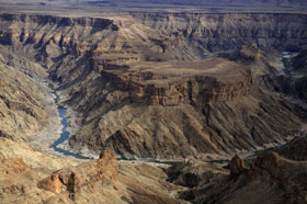 The
canyon is part of a Nature Conservation Park. The gate is situated at
the restcamp Hobas. From there, you have to drive another 10 kilometres
to the actual Canyon which offers a stunning view of "Hell's Bend".
The
canyon is part of a Nature Conservation Park. The gate is situated at
the restcamp Hobas. From there, you have to drive another 10 kilometres
to the actual Canyon which offers a stunning view of "Hell's Bend".
The Fish River Canyon has become a popular hiking destination. However,
hikes require good physical health and should only be undertaken during
the cooler winter months (between May and September). A permit must be
obtained. The Fish River trail covers a distance of 86km in the base of
the canyon, over 5 days, with absolutely no facilities whatsoever. You
carry everything with you and find whatever water you can in semi-permanent
pools.
Due to high summer temperatures which frequently exceed 45°C, the
hike is only open in winter. The season starts 15 April and ends 15 September
(winter time in the Southern Hemisphere). A medical certificate is required
to attempt the hike, and groups must consist of at least 3 participants.
At the end of the beautiful hike is the Ai-Ais hot springs where a well-deserved
dunking in therapeutic hot water springs awaits you.
Much easier hikes, in an equally beautiful seting, are offered in the bordering private Canyon Nature Park.
Geology
Upstream the river runs through horizontal dolomite strata. These strata
formed part of the canyon about 650 million years ago when plate movement
cracked the earth, the first process in the formation of the Fish River
Canyon.
Lower down, a granite complex system is exposed to form a characteristic river bed that results in forms like Fingerspitze. In this area, a fault runs north-south, which accounts for the gorge-like channel and the presence of hot sulphurous springs.
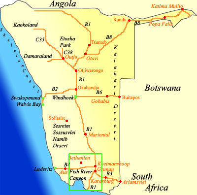
Map showing places to stay around Fish River Canyon
